17
$\begingroup$

When I lived in Darwin, Australia, I noticed that the Sun set in a slightly different direction to the West. In the evenings, I used to sit on a couch and watch TV. There was a huge window to my right and the setting sun would always shine bright into my face. So I moved a single vertical blind to block it out just about right. In the months of October/November I started noticing the sun shining into my eyes again. Neither the couch nor the blind had moved. After moving the blind again to block the sun, in a few months I would have to move the blind again. I was living alone and there is no way the blind or the couch would move.

When I lived in Canberra, Australia, I had the habit of stepping out of my house early in the morning. I would face the sun as soon as I stepped outside because it was too cold and I wanted the warmth of the sun on my eyes/face. I noticed again in October/November that my usual position of facing the sun was wrong. The sun would rise from a slightly different angle. So if earlier the sun was rising at 130 degrees from my door, it would now be rising at 110 degrees. The door faced the southeast, and because of the very narrow path and vegetation from my door I am very certain of my positioning.

I really don't know what this phenomenon is called. When I lived for so many years in other countries, I never noticed this. Am I just being silly or does the Sun rise/set differently every so many months?
$\endgroup$
7
  • 3
    $\begingroup$ MIT students celebrate this phenomenon, on days when the setting Sun shines down the axis of the longest corridors in the core campus buildings. Coming up next week! $\endgroup$
    – John Doty
    Commented Nov 4, 2020 at 17:04
  • 4
    $\begingroup$ Manhattanhenge is a more well-known example of this. $\endgroup$ Commented Nov 4, 2020 at 17:46
  • 2
    $\begingroup$ Legend says that the sun rise shines through the Box rail tunnel, near Bath, UK, on Brunel's birthday Box Tunnel Legend $\endgroup$
    – Nibor
    Commented Nov 5, 2020 at 8:49
  • 2
    $\begingroup$ The term solstice literally means "sun stop" and indicates the point at which the sun's path has reached its limit and starts moving back the other direction. $\endgroup$ Commented Nov 5, 2020 at 17:54
  • 1
    $\begingroup$ Coastal Californians that go to the same beach regularly to watch the sunset can easily tell that it moves $\endgroup$
    – JoelFan
    Commented Nov 6, 2020 at 8:21

6 Answers 6

22
$\begingroup$

The Sun rises and sets at a different point on the horizon every day. The change is small, so without careful observations, it may take several days or weeks to be fully aware of the change. Mathematically, the position of rising/setting can be found from the following formula: $$\cos(\theta) = -\frac{\sin(declination)}{\cos(latitude)}$$ where

  • $\theta$ is the angle measured from due south to the point on the horizon where the object rises. (The angle is the same for rising and setting, if you ignore the change in the Sun's declination during the day.)
  • declination changes from approximately +23.5 and -23.5 degrees for the Sun during 6 months (southern hemisphere winter to summer) and then from -23.5 to +23.5 during the next 6 months. The reason the declination changes is because the Earth's north pole is tilted 23.5 degrees toward the Sun at the June solstice (making the Sun's declination +23.5), the north pole is tipped 23.5 degrees away from the Sun at the December solstice (Sun's declination -23.5) and changes each day in between the solstices.
  • latitude is the observer's latitude.

From 35° S latitude (latitude = -35), the winter Sun would rise at $\theta=119$ from due south (or 61° from due north, approximately ENE). The summer Sun would rise at $\theta=61$ from due south (or 119° from due north, approximately ESE). The range is 119-61=58° along the horizon.

At latitudes closer to the equator (0° latitude), the difference is smaller. The range is approximately 47° along the horizon when at the equator. At latitudes closer to the poles, the range becomes larger. At the Arctic and Antarctic Circles, the range is the largest that it can be: 180° (at least mathematically). At these high latitudes, the apparent diameter of the Sun and refraction become important to calculate the precise location of rising.

$\endgroup$
4
  • $\begingroup$ Indeed. As far as I can tell, this is just a conversion between equatorial and altazimuth coordinates. One way to visualize it is to launch Stellarium and to enable the equatorial grid. It's easy to see where +23.5 and -23.5 intersect the horizon. By playing with the latitude of the obverver, we see how the equatorial grid rotates relative to the horizon, and how the intersections gets further apart when close to the poles. $\endgroup$ Commented Nov 5, 2020 at 0:34
  • 1
    $\begingroup$ It’s interesting that this formula directly shows that on the equinoxes the sun sets due west everywhere on earth, except at the poles, where it doesn’t set—the formula is undefined. $\endgroup$
    – prl
    Commented Nov 5, 2020 at 10:32
  • 2
    $\begingroup$ I love the math. But, based on the text of the question (and more specifically, how the question sounds), I'm not sure you've made it easily and explicitly clear that the sun rises and sets at a different point because of the combination of the earth's tilt and the position of the earth along the sun's orbit. You kind of just dove right in to the details, but the details might not make sense to someone who hasn't made the high-level connection yet. It kind of seems like most of the answers so far suffer from this. $\endgroup$
    – Ellesedil
    Commented Nov 6, 2020 at 2:17
  • $\begingroup$ I noticed this at my old house, where the front window pointed due east. You couldn't watch TV during the day at some times of the year without closing the blinds. $\endgroup$
    – RonJohn
    Commented Jun 12, 2023 at 12:34
18
$\begingroup$

You're not silly1, it certainly swings back and forth (North and South) one full cycle every year. It's directly related to why days are longer in the summer and shorter in the winter.

I am no expert, but some say that Stonehenge and other ancient "observatories" are supposedly set up to do exactly what it is you do, except much more carefully and quantitatively, to time things like crop plantings.

For more on that see Wikipedia's List of archaeoastronomical sites by country

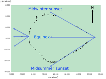
One example in Australia is Wurdi Youang, and the drawing below nicely highlights exactly what you are describing!

Wurdi Youang Source


1at least in this regard :-)

$\endgroup$
9
  • 3
    $\begingroup$ @happybuddha why would they get it wrong? They had plenty of time to look at the stars in order to orient themselves. And if it takes multiple year to build a temple, it's no big deal to wait for the equinoxes to perfectly align E-W. $\endgroup$ Commented Nov 5, 2020 at 0:37
  • 7
    $\begingroup$ And your ancient temple builder didn't start making observations because they needed them to build their idea of a whatever-pointing temple; they built the temple that way because they already knew the directions involved. $\endgroup$
    – chepner
    Commented Nov 5, 2020 at 13:00
  • 3
    $\begingroup$ A few more exapmples. At sunset on the winter solace, the Sun shines directly into Maes Howe. Around 30 May and 12 June, the Sun will sun shine directly along (Manhatten's streets)[en.wikipedia.org/wiki/Manhattanhenge] $\endgroup$
    – CSM
    Commented Nov 5, 2020 at 17:27
  • 1
    $\begingroup$ @EricDuminil The equinoxes can align - but the Idol isn't necessarily facing the rising sun all the time - which I think is necessary. I have asked this question else where too : engineering.stackexchange.com/q/38529/29293 $\endgroup$ Commented Nov 5, 2020 at 23:30
  • 2
    $\begingroup$ @happybuddha each Stack Exchange site has a different "culture", it's a little bit like going from one country to another. In Engineering SE they will want to see an engineering problem explained clearly, ideally in engineering terms. Maybe focus less on the religious aspects and details, and add more about the exact mechanical behavior you need. Right now I can't figure out what you are describing there. $\endgroup$
    – uhoh
    Commented Nov 5, 2020 at 23:55
13
$\begingroup$

This answer is a supplement to the existing answers.

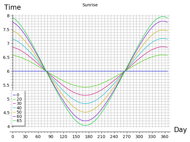
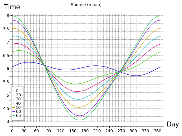
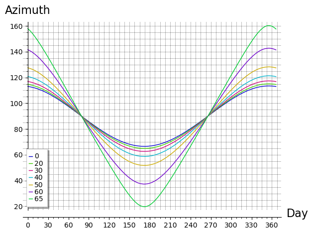
I looked around for nice graphs showing the sunrise azimuth over the year for various latitudes, but I couldn't find anything suitable. So I just wrote a couple of small Python scripts, using Sage / Matplotlib to do the plotting.

Sunrise azimuths for various latitudes

Sunrise azimuths for various latitudes

Sunrise times for various latitudes

Sunrise apparent times for various latitudes

That graph is for apparent solar time (i.e., sundial time). Here's one for mean solar time (clock time).

Sunrise Mean time for various latitudes

You can play with the azimuth plotting script on the SageMathCell server here.

The script is actually encoded in the URL. It's a bit cryptic & terse to save space. Just type a comma-separated list of latitudes into the box & it'll plot the corresponding curves.

Hopefully, I haven't made any coding or algebra errors. ;) I used the azimuth formula given in John Holtz's answer, and I got the declination equation from Wikipedia's article on the Position of the Sun, modified to use slightly more accurate values for the obliquity of the ecliptic and the Earth's orbital eccentricity. In the script,

  • dpy is days per year
  • sinOE is the sine of the obliquity of the ecliptic
  • ecc2 is twice the eccentricity
  • mam is the mean orbital motion
  • n is the day number, with 0 = midnight on New Years Day
  • lat is the latitude
  • sindecl calculates the sine of the declination
  • sraz calculates the sunrise azimuth

Here's a simpler version, which just plots a single curve.

Here's the script that plots apparent sunrise times.

This script's for the mean sunrise times. And here's one for the Equation of Time, the previous script uses the formula from this one to convert apparent time to mean time.


Those curves are calculated for an observer at longitude 0° (pretty much), but they're accurate for any longitude. (At any given longitude there's a small displacement that's almost constant over the year, apart from effects due to the variations in the Sun's speed along the ecliptic, aka the Equation of Time). They do not account for the observer's height above sea level (and hence the distance to the horizon) or the angular size of the sun, or atmospheric refraction: I just wanted to show the general trend. But as John Holtz notes, refraction does have a noticeable affect on sunrise time and the Sun's apparent altitude, especially at higher latitudes, where the Sun makes a lower angle to the horizon.

If you ask those scripts to plot curves for latitudes in the Arctic or Antarctic circles, they will do their best, but will print error messages warning that they couldn't plot some points. I didn't want to waste space in the scripts handling days when the Sun doesn't rise. ;)

$\endgroup$
4
  • $\begingroup$ These are nice! I'm almost tempted to post my Desmos interactive graphs simulating the suns elevation over the day where you can vary the latitude and day of year. But they're not quite on subject for the question. I guess I'll have to wait. $\endgroup$
    – JonathanZ
    Commented Nov 4, 2020 at 22:44
  • 1
    $\begingroup$ Thanks, @Jonathan! Yes, this question is about azimuth, not altitude, so your graphs would be a bit off-topic (but maybe you can ask a self-answered question, or find an old relevant question that could do with some graphs). FWIW, Sage does have some animation capabilities. I made a version with a slider for the latitude, but unfortunately the slider doesn't work too well on touchscreen devices: you can click the slider to a new position, but you can't grab it & slide it. And the clicking doesn't give you much precision. Very frustrating! $\endgroup$
    – PM 2Ring
    Commented Nov 4, 2020 at 23:00
  • $\begingroup$ That's good to know (about Sage). Desmos has very nice, smooth, and precise sliders, but the syntax for entering formulas is a real pain and pretty limited. $\endgroup$
    – JonathanZ
    Commented Nov 4, 2020 at 23:29
  • $\begingroup$ I couldn't decide which year length I ought to use for dpy (days per year). Wikipedia isn't consistent: some formulae use 365.25, some 365.24. So I originally went with the Gregorian length, 365.2425. However, I used the anomalistic year in the Equation of Time & mean sunrise time scripts. Another reasonable option is the mean tropical year. OTOH, I guess it's hardly relevant in calculations that completely ignore years. ;) $\endgroup$
    – PM 2Ring
    Commented Nov 6, 2020 at 13:01
7
$\begingroup$

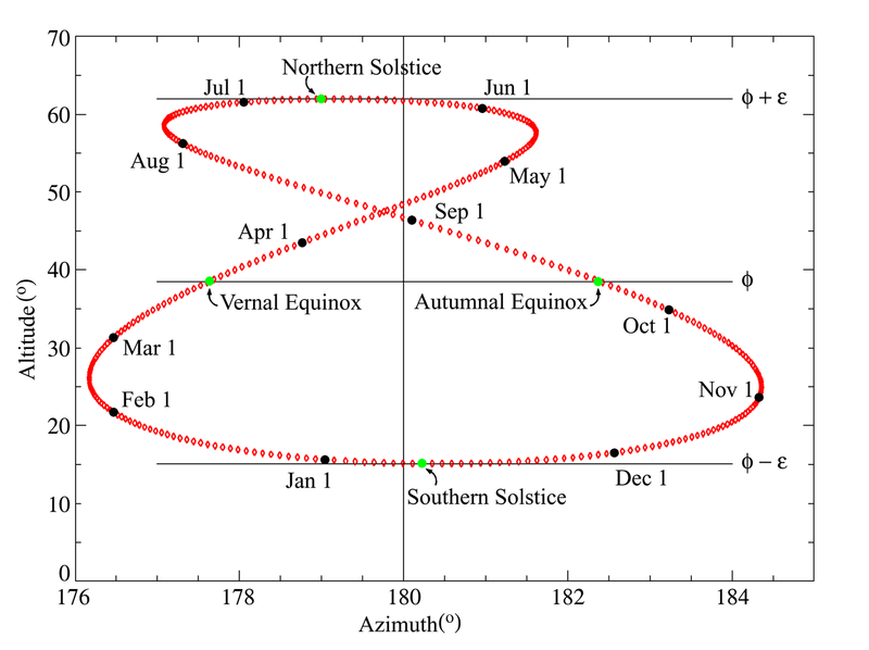
The Sun does indeed drift across the sky throughout the year, not only rising higher in the summer and lower in the winter, but also varying along an east-west axis. This can be shown by observing the Sun at the same time each day throughout the year, and seeing that it changes position. This shape is called an analemma, and is a result of the earth's axial tilt and orbital eccentricity around the Sun.

Here's a diagram showing the position of the Sun at noon throughout the year, as observed from the Royal Observatory in Greenwich. Most people are aware of the change in altitude between summer and winter, but the fact that the angle of the sun varies side-to-side may be less well-known.

enter image description here

Now, this figure shows the position of the sun at a fixed time of day over the course of the year. But the question relates to the position of the sun at sunrise, which is clearly not fixed throughout the year. To answer the original question of if the sunrise "moves", you can imagine drawing an analemma for any time of day - let's pick a time that's before sunrise for part of the year, and after sunrise for another part of the year (let's say 6am). In this case, the whole curve shifts downward, and the bottom part of the analemma drops below the horizon, showing that indeed, for some parts of the year, the sun will be visible at 6am, but at other parts of the year, the sun will not be visible at 6am. Furthermore, we see the curve drop below the horizon at two different spots - this shows that there are two dates at which sunrise is at (approximately) 6am, and that the sun will rise at different azimuth on those days.

It's a little more complicated if we want to draw the "sunrise analemmas" over time, since we'll have a figure-8 shape that drifts upward as sunrise becomes earlier, following the position of the sun as it moves across the sky. It's not as easy to visualize, but that series of analemmas will drop below the horizon at different points, showing that the sunrise does move throughout the year. This shape, which is traced out by the intersection of a series of analemmas with the horizon, is not an analemma itself. The example of two dates with the same sunrise time is much easier to visualize with a single analemma.

$\endgroup$
15
  • 1
    $\begingroup$ @RBarryYoung The OP is asking about the Sun's azimuth at sunrise, not its azimuth at mean noon. The info in this answer is important, though. The Sun crosses the meridian (the north-south line) every day at local solar noon (aka "high noon"), but that's not equal to mean solar noon, due to the Equation of Time. And then there's a further adjustment if you aren't located at the meridian of your time zone (plus a possible adjustment for Daylight Saving). I discuss the details of this issue in this Physics.SE answer. $\endgroup$
    – PM 2Ring
    Commented Nov 4, 2020 at 21:24
  • 1
    $\begingroup$ I'm not convinced that the analemma plays any role for this question. It is about the azimuth of sunrise and sunset, not their times. For a given latitude, only the sun declination plays a role. For the above question, only the vertical motion is relevant in the analemma and you can ignore the horizontal motion. $\endgroup$ Commented Nov 5, 2020 at 0:22
  • 1
    $\begingroup$ I calculated the azimuth of sunrise for each day, at my location. I also calculated the sun position at noon for each day. Here's a plot of sunrise azimuth vs elevation at noon : i.sstatic.net/Jwlrc.png There's no analemma anymore, and the equation of time doesn't have any influence on sunrise azimuth. I'm not sure how you could correct your answer, since it appears to be based on a false premise. Sorry to rain on your parade! $\endgroup$ Commented Nov 5, 2020 at 12:43
  • 2
    $\begingroup$ OP was only concerned about the position of the sun during sunrise and sunset. By definition, it only happens when the sun elevation is 0, and the time is not relevant at all for the azimuth. The azimuth at sunrise only depends on the declination, which is independent of the sun azimuth at noon. The question can be perfectly answered without analemma or sunrise time (see others answers, e.g. from PM2Ring or JohnHoltz), and adding those concepts doesn't help at all and only obfuscates the situation. Sorry for the harsh feedback. $\endgroup$ Commented Nov 5, 2020 at 16:07
  • 1
    $\begingroup$ @Eric I get what you're saying (& agree that the analemma is irrelevant here because we want the Sun's azimuth direction at sunrise time, not some particular clock time). We do need the eccentricity to get the Sun's declination (or ecliptic longitude) for the day, because the eccentricity causes the Sun's ecliptic speed to vary. (And then the obliquity causes the Sun's equatorial speed to vary, and the Equation of Time shows both effects). But once we have the declination, the sunrise azimuth is a simple function of the declination and the observer's latitude. $\endgroup$
    – PM 2Ring
    Commented Nov 6, 2020 at 13:15
3
$\begingroup$

I hope someone can come along and make this more precise, but I'm pretty sure the effect is greater the further you move away from the equator. So it would be more noticeable in Canberra (35° S) than in Darwin (12° S). Do you know the latitudes of the previous places you lived?

$\endgroup$
0
2
$\begingroup$

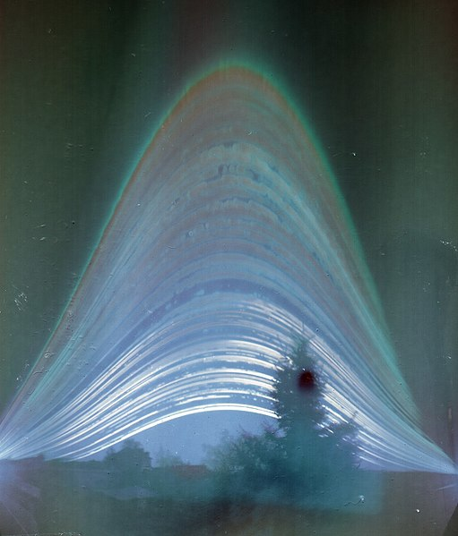
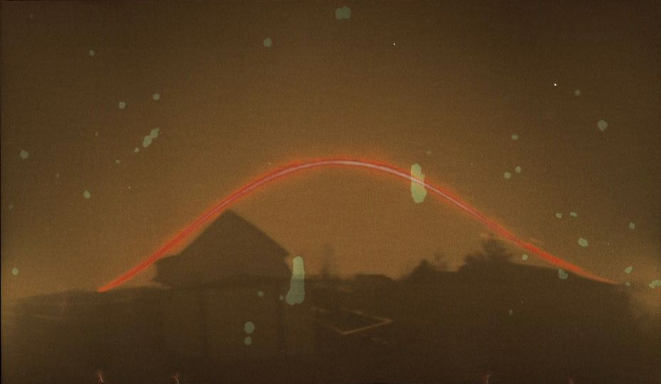
To augment many of the good answers already: A great way to view and record this effect is called a Solarigraph. (Often also referred to as a solargraph, solargraphy, or solarigraphy).

This is a pinhole camera, usually just a soda can with a hole poked in it, and a piece of photographic paper left out for a long period of time. Usually at least 1 day, and most often from one solstice to the next solstice. The Sun is bright enough to form an image directly on the paper, so there is no development process needed.

When left out from solstice to solstice, lines are formed on the photo paper for each day. The lines tend to run together near the solstices, and are farthest apart near the equinoxes. Breaks in the lines are caused by clouds. Most long exposures will show some form of water damage, as moisture exposure is part of the image forming process. When left out spanning a solstice, the lines often overlap.

Below are a few examples, but an image search will reveal many, many more.

Solargraph from Sashegy - Budapest, 2014.01.01 - 2014.12.31 (1).jpg Original image link enter image description here

A 7 day solarigraph near the winter solstice enter image description here

A three day solarigraph near the equinox. The lines that look like contrails are reflections due to the use of glossy photo paper. enter image description here

$\endgroup$

You must log in to answer this question.

Not the answer you're looking for? Browse other questions tagged .